
 출생")
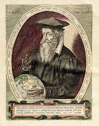
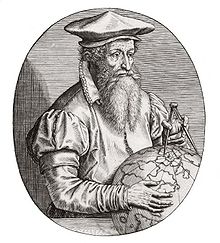
1512년 3월 5일, 네덜란드의 지리학자 ‘근대 지도학의 창시자’ 게라르두스 메르카토르 (Gerardus Mercator, 1512 ~ 1594) 출생
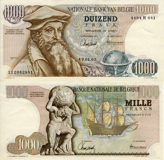
게라르두스 메르카토르 (라: Gerardus Mercator, 네: Gerard de Kremer, 1512년 3월 5일 ~ 1594년 12월 2일)는 플랑드르 (현대 벨기에 지방)에서 태어난 네덜란드의 지리학자이다. 아피아누스에게서 배우고, 1534년 루뱅에 지리학 연구소를 설립, 플랑드르 지방을 측량하여 지도를 만들었다. 프톨레마이오스·클라우디우스의 방법에 의하여 1538년 세계 지도를 제작하였으며 지구의와 천구의도 만들었다. 1569년 메르카토르 도법에 의한 세계 지도를 제작하였는데, 이 도법은 방위를 바르게 표시하고, 항해에 편리하여 항해 도법으로 불린다. 1558년 이전에 나온 지도들을 기초로 하여 대지도를 계획하였으나, 이 일은 그의 아들이 계승했다.
– 게라르두스 메르카토르 (Gerardus Mercator)
.출생: 1512년 3월 5일, 벨기에 Kruibeke Rupelmonde
.사망: 1594년 12월 2일, 독일 뒤스부르크
.국적: 네덜란드, 벨기에
.배우자: 바바라 쉘레켄스
.자녀: Rumold Mercator, 아놀드 메르카토르, Emerentia Mercator, 카타리나 메르카토르 등
.저서: Atlas or cosmographical meditations upon the fabric of the world and the figure of the fabrick’d, 더보기
.학력: Old University of Leuven (1530 ~ 1532년) 등
게라르두스 메르카토르 (Gerardus Mercator, 1512 ~ 1594)는 16세기 네덜란드의 지리학자로 근대 지도학의 시조로 일컬어진다. 대(大)유럽·영국 지도, 메르카토르 세계지도를 제작했다. 메르카토르 도법의 창안자로 이를 항해도에 처음 사용했다.
그은 루뱅 대학에서 수학·천문학·지리학을 공부하고 1538년에 처음으로 세계지도를, 41년에는 지구의를, 51년에는 천구의를 제작했다.
1552년 독일의 뒤스부르크에 연구소를 설립하고 지도 제작에 전념했다. 54년에는 15매로 구성된 대유럽지도를, 64년에는 8매로 된 영국지도를 제작했다.
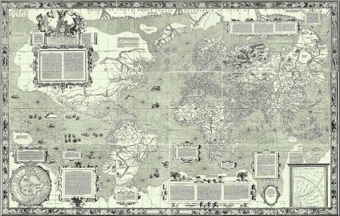
1569년에는 유명한 메르카토르 세계지도를 완성했다. 메르카토르 도법 (圖法)의 투영법은 그가 창안한 것은 아니지만 이 도면을 항해도로 사용케 한 것은 그가 처음이다. 만년에는 많은 지도책의 제작에 전념했다.
- 메르카토르 도법
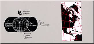
메르카토르 도법은 1569년 세계지도 (World Map) 제작과 함께 발표된 지도 투영법 (map projection)으로, 구에 원통 (cylinder)을 씌워 평면 투영함으로써 경선 (또는 자오선, meridian)의 간격은 고정되어 있지만
위선의 간격을 조절해서 각도 관계가 명확하도록 정의한 것이다.
원통중심도법과 원통정적도법을 절충한 이 도법은, 경선의 간격은 고정되어 있으나 위선의 간격을 조절하여 각도관계가 정확하도록(정각 도법) 되어 있다.
따라서 적도에서 멀어질수록 축척 및 면적이 크게 확대되기 때문에 위도 80′ ~ 85′ 이상의 지역에 대해선 사용하지 않는다.
이 도법의 가장 큰 특징은 지도 상 임의의 두 지점을 직선으로 연결하면 항정선과 같아진다는 것이다.
따라서 항해용 지도로 많이 사용해 왔다. 또 방향이나 각도 관계가 정확하므로 해류나 풍향 등을 나타내는 지도에도 많이 사용한다.
○ Works
– Globes and instruments
1536 Gemma Frisius terrestrial globe.
1537 Gemma Frisius celestial globe.
1541/1551 Terrestrial and celestial globes.
– Maps
1537 Holy land
1538 World Map
1554 Europe 1554 version. 1595 version.
1564 British Isles, 1570 atlas Archived
1564 Lorraine (Lotharingia)
1569 world map Full details
1570–1572 Atlas of Europe.
1578 Ptolemy’s Geographia
1585 Atlas Galliae, Belgii Inferioris, Germaniae.
1589 Atlas Italiae, Sclavoniae, Grecia.
1595 atlas in the collection of the Royal Library of Belgium
1595 Atlas (published posthumously by Rumold Mercator)

– Books
Mercator, Gerardus (1540), Literarum latinarum, quas italicas, cursorias que vocant, scribendarum ratio (How to write the Latin letters which they call italic or cursive), Antwerp, OCLC 63443530 Available online at the Library of Congress and Das Münchener Digitalisierungszentrum. It may be downloaded as a pdf from the latter. This book is the subject of a monograph which includes a translation of the text (Osley 1969).
Mercator, Gerardus (1554), Declaratio insigniorum utilitatum quae sunt in globo terrestri : coelesti, et annulo astronomico ad invictissimum romanum imperatorem Carolum Quintum. (A description of the most important applications of the terrestrial and celestial globes and the astronomical ring. For the most invincible Roman Emperor Charles V.), Duisburg. Reprinted in 1868 with a commentary by Jean van Raemdonck. (OCLC 459842538). For the Latin text and a German translation see Krücken (1996). A rough (partial) translation is on wikiquote
Mercator, Gerardus (1569), Chronologia, Hoc Est Temporvm Demonstratio Exactissima, Ab Initio Mvndi, Vsqve Ad Annvm Domini M.D.LXVIII. Ex Eclipsibvs Et Observationibvs Astronomicis omnium temporum concinnata. (‘A chronology, a very accurate of recorded time from the beginning of the world until AD1568. Elaborated from astronomical observations of eclipses for all times.), Duisburg: Arnoldi Birkmanni, OCLC 165787166. There are PDF downloads, at the Bayerische Bibliothek (title page) and also the Hathi Trust (catalogue and title page).
Mercator, Gerardus (1592), Evangelicae historiae quadripartita monas sive harmonia quatuor Evangelistarum. (Harmonization of the Gospels.) Many other copies listed at World Cat.

참고 = 위키백과, 나무위키
크리스천라이프 편집부