
 별세")
1839년 8월 28일, 영국의 지질학자 윌리엄 스미스 (William Smith, 1769 ~ 1839) 별세
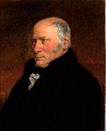
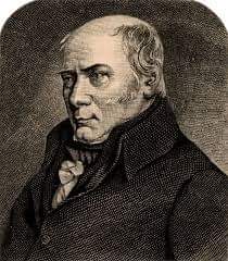
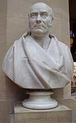
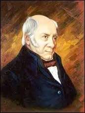
윌리엄 스미스 (William Smith, 1769년 3월 23일 ~ 1839년 8월 28일)는 영국의 지질학자이다.
산업 혁명의 진행에 따라 활발하게 진행되던 운하·항구·다리의 공사를 감독하는 동안, 지층과 화석을 연구하여 《지층학 원리》를 저술하였다.
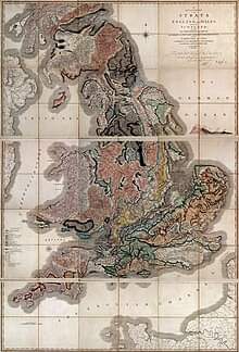
1815년 잉글랜드·웨일스·스코틀랜드를 조사하여 영국의 지질도를 완성하였다. “영국 지질학의 아버지”로 불린다.
○ 생애 및 활동
윌리엄 스미스는 1769년 3월 23일 영국 옥스퍼드셔 처칠의 작은 마을에서 대장장이의 아들로 태어났다.
스미스는 여덟살 때 아버지를 여의고, 이후 얼마간 삼촌의 손에서 자라게 된다. 넉넉지 않은 형편 때문에 대학에 진학할 수도 없는, 그저 평범한 소시민으로 자라났다.
그러나 그에게는 남달리 영민한 구석이 있었다. 바로 파여진 땅의 단면을 보고, 또는 화석을 통해 지층의 차이를 알아챌 수 있는 능력, 나아가 지층의 변화와 차이를 통해 보이지 않는 부분까지를 논리적으로 재구성할 수 있는 능력이었다.
게다가 그는 여행을 좋아하고 한 가지 주제를 집요하게 파고드는 성격이 있었다.
스미스가 훗날 세계 최초의 ‘지질학 지도’를 만들 수 있었던 데는 그의 이런 능력과 기질이 절대적인 역할을 했다.
1790년대 초반 스미스는 탄광의 측량사로 일하면서 지하세계에 처음으로 접근했다.
스미스는 어느 탄광이든 지층이 일정한 패턴으로 나타나고, 일정한 경사를 이룬다는 사실을 발견했다.
그가 발견한 암석층은 모두 남동쪽으로 기울어 있었으므로, 그는 지표면을 평평하게 깎는다면 가장 오래된 암석층이 북서쪽에, 가장 새로운 암석층이 남동쪽으로 갈 것이라고 생각했다.
오늘날 스미스의 업적을 폄훼하는 사람들은 “스미스가 운 좋게도 너무 알아보기 쉬운 배열의 지층에 접근했다”고 말하지만 당시의 많은 사람은 그런 배열을 보면서도 그것을 하나의 ‘이론’으로 발전시킬 생각을 하지 못했다.
스미스는 지층의 변화를 지도 위에 표시해 가며 자신의 생각을 발전시켰다. 그의 노력은 20년에 걸쳐 계속됐다. 측량으로 번 돈을 쏟아붓기도 하고, 지인의 도움을 받기도 하고, 여기저기서 돈을 끌어다 쓰기도 하며 마차를 타고 영국 방방곡곡을 다녔다.
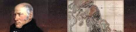
결국 1815년 스미스는 드디어 세계 최초의 ‘지질도’를 만들게 된다.
윌리엄 스미스 (William Smith)는 1839년 8월 28일에 별세했다.
○ Legacy
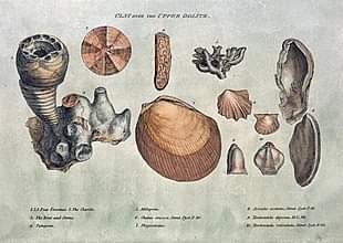
William Smith’s fossil collection that helped him produce the first geological map, on display in the British Museum
The first geological map of most of Great Britain, much copied in his time, and the basis for all others.
Geological surveys around the world owe a debt to his work.
His nephew John Phillips lived during his youth with William Smith and was his apprentice. John Phillips became a major figure in 19th century geology and paleontology—among other things he is credited as first to specify most of the table of geological eras that is used today (1841).
A crater on Mars is named after him. (see List of craters on Mars: O-Z#S)
The Geological Society of London presents an annual lecture in his honour.
In 2005, a William Smith ‘facsimile’ was created at the Natural History Museum as a notable gallery character to patrol its displays; others were Carl Linnaeus, Mary Anning, and Dorothea Bate.
His work was an important foundation for the work of Charles Darwin.
The Rotunda Museum in Scarborough was re-opened as ‘Rotunda – The William Smith Museum of Geology’, on 9 May 2008 by Lord Oxburgh; however, the Prince of Wales visited the Rotunda as early as 14 September 2007 to view the progress of the refurbishment of this listed building.
A building at Keele University containing the Geography, Geology and the Environment department is named after two William Smiths, both influential in the development of mapping. The first William Smith (1546?–1618) laid the foundations of the conventions of county mapping and of urban cartography. The second William Smith commemorated in the building’s name is William Smith the author of the first geological map of England and Wales and subject of this article.
참고 = 위키백과, 나무위키
크리스천라이프 편집부